

WORLD NEWS | EARTHQUAKE
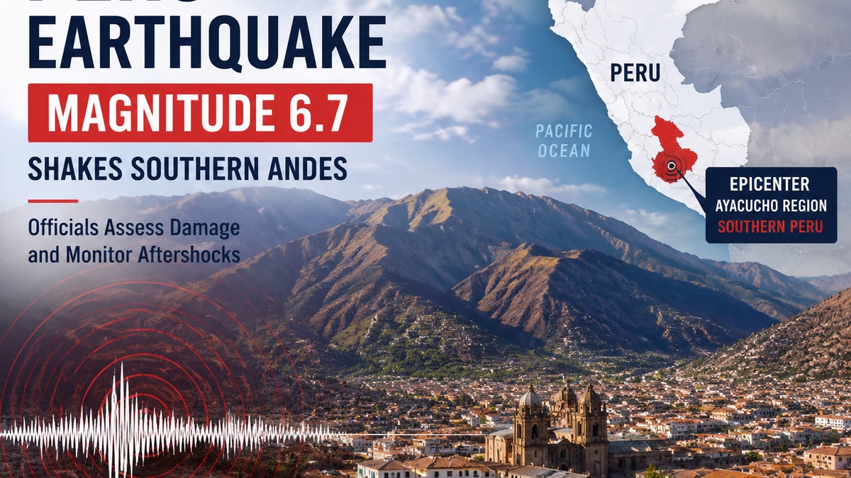
Peru Earthquake: Magnitude 6.7 Quake Shakes Southern Andes as Officials Assess Damage
A powerful earthquake struck Peru’s southern Andes on Thursday, sending tremors across several regions as emergency officials evaluated possible damage and monitored for aftershocks.
By Ava Thompson, Las Vegas News
Published: August 20, 2026
Peru Earthquake: At a Glance
- Magnitude: 6.7
- Location: Southern Andes region of Peru
- Epicenter: Near the Ayacucho region
- Impact: Residents reported strong shaking across multiple areas
- Response: Authorities began damage assessments and continued monitoring for aftershocks
Strong earthquake shakes Peru’s southern Andes
A magnitude 6.7 earthquake struck Peru’s southern Andes on Thursday, causing strong shaking across parts of the country and prompting emergency officials to begin assessing the impact.
According to data from the U.S. Geological Survey (USGS) , the earthquake occurred in southern Peru, with the epicenter located in the Ayacucho region. The tremor was strong enough to be felt across surrounding communities as seismic waves traveled through the Andes.
The earthquake was reported during a period of increased attention on seismic activity in the region, where communities regularly prepare for earthquakes due to Peru’s location along one of the world’s most active tectonic zones.
Residents report shaking across multiple regions
Residents in affected areas reported feeling significant movement as buildings shook and people moved outdoors as a precaution.
Earthquakes of this magnitude can be felt over wide distances, especially in mountainous regions where geological conditions can influence how seismic waves travel.
Emergency agencies continued collecting reports from communities near the earthquake zone while evaluating whether homes, roads, public buildings, or other infrastructure sustained damage.
Officials monitor damage and possible aftershocks
Following the initial earthquake, authorities began reviewing reports from local governments and emergency response teams.
Officials warned residents to remain alert because aftershocks can follow a major earthquake and may occur hours or days after the initial event.
Peru’s national seismic monitoring agencies continued tracking activity and providing updates as additional information became available.
Earthquake damage reports continue to develop
Initial earthquake reports often change as emergency crews reach more remote communities and conduct detailed inspections. In mountainous areas such as Peru’s Andes region, difficult terrain and limited access can delay assessments of roads, homes, public buildings, and other infrastructure.
Officials typically begin with preliminary reports from local authorities and residents before conducting more extensive evaluations. Damage assessments may continue for hours or days after a major earthquake as engineers inspect structures and emergency teams review conditions on the ground.
Authorities are also monitoring whether aftershocks create additional risks, particularly in communities located near the earthquake’s epicenter. Residents are encouraged to follow guidance from emergency officials and report any damage through official channels.
Peru’s history of major earthquakes
Peru has a long history of significant earthquakes because it sits along the Pacific Ring of Fire, a region known for intense tectonic activity. The country’s western edge is shaped by the ongoing movement of the Nazca Plate beneath the South American Plate, a process that frequently produces earthquakes.
Some of Peru’s most destructive earthquakes have caused widespread damage and highlighted the importance of earthquake-resistant construction, emergency preparedness, and early warning systems.
The country continues investing in seismic monitoring and public safety programs designed to help communities respond more effectively when major earthquakes occur.
How authorities measure earthquake risk
Scientists use networks of seismometers and satellite-based technology to detect earthquakes, estimate their strength, and analyze potential impacts.
The U.S. Geological Survey (USGS) measures earthquakes using seismic data collected from monitoring stations around the world. These measurements help determine an earthquake’s magnitude, location, depth, and potential effects.
In Peru, the Instituto Geofísico del Perú (IGP) operates national seismic monitoring systems that provide earthquake information and analysis for government agencies and the public.
By combining real-time seismic data with information from local officials, scientists can better understand earthquake behavior and provide more accurate updates as situations develop.
Why earthquakes are common in Peru
Peru is located along the Pacific Ring of Fire, an area surrounding the Pacific Ocean where many of the world’s earthquakes and volcanic eruptions occur.
Much of Peru’s seismic activity is caused by the movement of the Nazca Plate beneath the South American Plate. This process, known as subduction, generates frequent earthquakes along the western edge of South America.
The country has experienced several major earthquakes throughout modern history, including destructive events that have caused widespread damage and loss of life.
What happens next
Scientists and emergency officials will continue analyzing earthquake data, reviewing damage reports, and monitoring for additional seismic activity.
Residents in affected areas are encouraged to follow instructions from local authorities and remain prepared for possible aftershocks.
The latest official earthquake information is available through the Instituto Geofísico del Perú (IGP) and the U.S. Geological Survey earthquake monitoring system .
“Earthquakes can continue to evolve after the first major shaking. Emergency officials typically monitor seismic activity for additional tremors and changing conditions.”
Frequently Asked Questions
How strong was the Peru earthquake?
The earthquake was measured at magnitude 6.7 by the U.S. Geological Survey.
Where did the Peru earthquake happen?
The earthquake occurred in southern Peru, near the Ayacucho region of the Andes.
Was there a tsunami warning?
No tsunami threat was reported following the earthquake.
Sources & Reporting
This article was independently written by Las Vegas News based on publicly available information from official earthquake monitoring agencies and international reporting.
- U.S. Geological Survey (USGS) Earthquake Hazards Program
- Instituto Geofísico del Perú (IGP)
- Associated Press reporting distributed through international news partners
- International reporting from ABC News and USA Today used for background verification